
-
Intercontinental Highway Map Activity
In this activity you will examine a map with a proposed intercontinental highway route. Based on your knowledge of physical features and climate and vegetation regions, you will need to provide a rationale, that includes at least three reasons, for why the World Bank and African leaders might have rejected the proposed highway. In addition, you will provide at least three solutions for the World Bank and African leaders to consider as an alternate route. Your rationale and solution should be written in letter form.Activity Handout:To access a copy of the handout for this activity, click here. (an updated version with more detail is coming soon!)For information about the population of African cities:CultureGrams:To learn more about different countries of Africa check out the CultureGrams database which can be accessed by clicking here. Remember if you are trying to access this database from home, you will need to log in using the username and password that can be found on the purple Electronic and Digital Resources paper that your parents received at Open House. If you cannot find this sheet, please stop by the Library for another copy.Maps of Africa:Here is the proposed route that has been rejected. You may draw your new route on this mapUse the maps here to help you analyze the proposed route for the intercontinental highway.Physical Features Map of Africa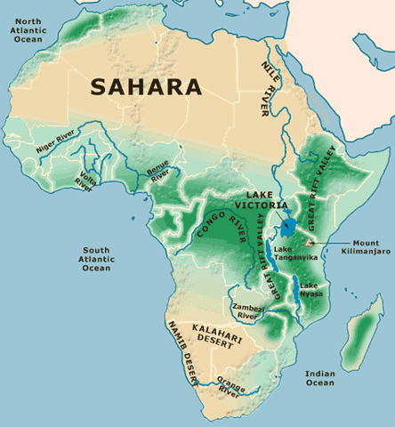
Last Modified on November 16, 2015